






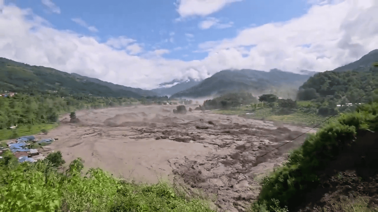
A catastrophic flash flood struck the Nepal-Tibet (China) border region on Wednesday, August 26, 2026, primarily affecting Nepal’s Rasuwa district and downstream areas along the Bhote Koshi and Trishuli river systems, as well as Gyirong (Jilong) Port and related areas on the Tibetan side.
It caused widespread destruction of roads, bridges, houses, hydropower projects, and other infrastructure, with impacts extending into districts such as Nuwakot, Dhading, Chitwan, Gorkha, Tanahun, and Nawalparasi East. Water levels on the Trishuli River rose dramatically in places (e.g., up to about 9 metres in 30 minutes at some gauging points).
Latest News and Casualties (as of August 27, 2026)
Rescue and recovery operations are ongoing on both sides of the border, involving Nepal’s army, police, armed police force, helicopters (with landing limited initially by high water), Chinese emergency teams (hundreds of rescuers, vehicles, sniffer dogs, and boats), and international support offers. Nepal’s Prime Minister Balendra Shah has directed intensified efforts and evacuations of low-lying areas. China’s President Xi Jinping called for all-out search efforts and stronger monitoring/early-warning systems. The UN has indicated support with supplies and personnel.
- Death toll: Nepali police and reports put confirmed deaths in Nepal at around 157–165 (with bodies recovered across multiple districts, including significant numbers downstream in Chitwan). Chinese state media reported at least 3 deaths on the Tibetan side. The overall toll is expected to rise as searches continue.
- Missing: Hundreds to over 1,000 people are unaccounted for across both sides (figures may overlap and are evolving). Nepal has reported hundreds of tourists/travellers missing (earlier figures around 384–579, including large numbers of foreigners—e.g., Indians in the range of 100+, along with Americans, British, Australians, Canadians, Malaysians, South Koreans, and others from various countries). Many were pilgrims (including Kailash Mansarovar Yatra groups), trekkers, or border-area workers/staff (including security personnel). On the Tibetan side, Chinese reports cited hundreds missing (including foreign nationals).
- Other impacts: Significant damage to hydropower (hundreds of MW capacity affected, including operational and under-construction projects), roads/bridges (dozens of structures and kilometres of highway), power/communications, and local economies. Flood alerts were issued downstream in India’s Bihar and Uttar Pradesh due to rivers flowing into the plains (Narayani-Gandak system). Authorities have warned of possible secondary flooding.
Numbers continue to be updated as recovery proceeds and communications are restored; early reports started lower (initial confirmed deaths in the single digits to low dozens) and rose rapidly.
Reasons / Causes
The primary trigger was a large ice-rock avalanche (or glacial collapse/ice avalanche) high in the Himalayas, involving a substantial section of glacier (reports describe a chunk roughly 2,000 feet / ~600 metres wide) that broke away, fell a significant vertical distance (around 1 km / nearly 4,000 feet in some analyses), and generated a powerful debris-laden surge of ice, water, rock, and sediment into the Lhende (Lhende/Lende) Khola, a tributary of the Bhote Koshi River near the border (roughly 20 km northeast of Rasuwagadhi).
This rapidly created a wall of water and debris that surged downstream through narrow valleys and gorges. Scientists analysing satellite imagery (including from Planet Labs) and other data describe the glacier essentially snapping off in a relatively clean break; the impact pulverised ice into water and mobilised massive debris. The event was powerful enough to register seismically (initially reported as a ~4.4 magnitude earthquake, later clarified by the US Geological Survey as the landslide/debris flow itself generating energy equivalent to about magnitude 5.2; no tectonic earthquake occurred).
Possible sequence details and contributing factors:
- The avalanche debris may have temporarily dammed the river (landslide dam), allowing water to build up before a sudden release, amplifying the flood pulse. A residual blockage upstream has been noted, raising concerns about a potential second surge; evacuations and alerts have been issued in relevant areas (including on the Chinese side).
- Early official statements linked it to a possible earthquake triggering the avalanche, but subsequent seismic and satellite analysis shifted the consensus toward the glacial collapse as the direct cause (with the seismic signal resulting from the mass movement).
- A pure glacial lake outburst flood (GLOF) appears less likely as the primary mechanism based on initial assessments, though the broader Himalayan context involves melting glaciers and unstable lakes.
- Climate change and regional vulnerability: Warming temperatures in the rapidly heating Himalayas are destabilising glaciers (retreat, loss of snow/ice cover, melting that can infiltrate cracks and weaken ice/rock). Satellite observations noted vanishing snow cover in the days prior, consistent with warmer conditions. The high, steep, geologically young Himalayan terrain funnels water and debris quickly into narrow valleys, making flash floods highly destructive. This same area experienced a major flood roughly 14 months earlier (around July 2025). Nepal’s geography—steep slopes, numerous glaciers, monsoon influences, and active tectonics—makes it highly prone to such events, compounded by expanding glacial lakes and infrastructure in vulnerable corridors.
Full scientific confirmation of the precise sequence, exact volumes, and any secondary triggers will take further analysis of imagery, field data, and modelling (potentially weeks). Experts from institutions such as ICIMOD, universities (e.g., University of Calgary), and the USGS have contributed early assessments emphasising the ice avalanche and climate-related glacier instability.
Broader Context and Implications
This ranks among Nepal’s more severe recent disasters in terms of sudden impact and missing persons (particularly tourists and pilgrims in a key border/tourism corridor). It highlights ongoing risks in the Hindu Kush Himalaya region: glacier retreat, permafrost changes, more extreme precipitation in a warming climate, and the challenge of predicting and warning for high-mountain mass movements. Downstream countries monitor for cascading effects. Recovery will involve major infrastructure rebuilding (especially hydropower and connectivity), support for affected communities, and enhanced cross-border monitoring/early-warning systems.
Information is still developing; official sources in Nepal and China, along with international media and scientific updates, provide the most current figures. For the very latest casualty or rescue details, check reputable news outlets or government disaster agencies, as counts can change quickly during active operations.